Te Araroa
The length of New Zealand on foot, Cape Reinga to Bluff, running and hiking the whole trail in sandals against sex trafficking.
- Distance
- 3,054 kmThe length of New Zealand
- Days
- 87From 12 September to 8 December 2014
- Support
- NoneUnsupported, in sandals
- Tramped with
- DanMy friend and trail partner
- Running for
- AwarenessAgainst sex trafficking
- Recognition
- Runner-upOutdoor Hero of the Year
I've never had to call upon such deep determination and resolve in all my life.
Explore the route on a map Drop a pin anywhere and see the road in Street View.
In 2014 I walked and ran the length of New Zealand on Te Araroa, 3,054 km from Cape Reinga to Bluff, in Bedrock Sandals. My friend Dan and I set off from Cape Reinga on Friday 12 September, and it took 87 days. Along the way I raised money, with Rebekah Clews, who was also walking Te Araroa, for Tear Fund’s Project ACT, fighting human and sex trafficking.
I’ve never had to call upon such deep determination and resolve in all my life, especially after my injury. This would not have been possible without God’s grace, the wonderful help of trail angels, and above all my awesome friend Dan.
One day was so good I almost forgot it was my birthday: day 62.
The walk left a mark on my sandals too. After Te Araroa, Bedrock began prototyping and testing a new sandal line, the Cairn (their story). Dan’s photos from the trail are on his Instagram, @specialopz.
Before it, I trained in the monsoon in the Western Ghats and on the Annapurna treks in Nepal: how I trained for Te Araroa. What follows is the trail as I posted it at the time, from getting to the start to the finish at Bluff and a new year on Mt Doom.
In the press: NZ Herald, Newshub, Wilderness, The Outdoor Journal and RNZ Nights.
Getting to the start
I’m going on an adventure for the next four months with my friend Dan along New Zealand’s 3,000 km Te Araroa trail. Thank you to Bedrock Sandals, Gossamer Gear, Huckberry, NEMO Equipment and Yama Mountain Gear for the support.
Kiwi hospitality is insane. Carol gave Dan and me a ride from Auckland to Warkworth. She has travelled the world and was full of travel stories. It’s quite an adventure even getting to the start line at Cape Reinga to start our Te Araroa.
The night before we started, I wrote a walking song in my journal.
Even getting to the start line has become quite an adventure. Hitchhiking all the way to Cape Reinga from Auckland. Kiwis are so awesome. A lady stopped by and gave us hot muffins when she noticed us waiting for a ride. Got to Whangarei and pitched our tent for the night. Hoping for more good luck today!
Cape Reinga and Ninety Mile Beach
Weather: 13 to 15°C · 2 mm of rain · gusts to 85 km/hIt has begun. With the incredible hospitality of the Kiwis, Dan and I made it to the start line, Cape Reinga, to start hiking the Te Araroa trail.
Te Rerenga Wairua (Cape Reinga) and Spirits Leap: the afterlife is a spiritual concept shared by many cultures. Cape Reinga is the site of departure for Māori spirits. Cape Reinga represents the top of the North Island. For Māori, Cape Reinga is the most spiritually significant place in New Zealand.
An ancient pohutukawa tree and a lonely lighthouse mark this special place. It is here that after death, all Māori spirits travel up the coast and over the wind-swept vista to the pohutukawa tree on the headland of Te Rerenga Wairua.
They descend into the underworld (reinga) by sliding down a root into the sea below. The spirits then travel underwater to the Three Kings Islands where they climb out onto Ohaua, the highest point of the islands, and bid their last farewell before returning to the land of their ancestors, Hawaiiki-A-Nui.
Descending onto Ninety Mile Beach, the very first section of tramping Te Araroa in New Zealand.
A zero day in Ahipara
Weather: 13 to 15°C · 1 mm of rain · gusts to 44 km/hKiwi generosity helped us get to the start line, and we started our hike on Friday evening. Te Araroa really put us to the test. Finished hiking Ninety Mile Beach and decided to take a zero day in Ahipara before heading into the forest tomorrow. A random Kiwi picked us up and opened up his house for the night.
I played 18 holes of golf on my rest day and it was awesome. Just about 2,900 km left :)
The Herekino and Raetea forests
Weather: 9 to 17°C · 1 mm of rain · gusts to 52 km/hOut of the Herekino and Raetea forests. Te Araroa put us to a real test. Freezing cold, heavy downpour, knee-deep clay mud and insane downhills for 40+ miles. Covered in mud from head to toe. Had to be Tarzan in some sections, but my muddy hands didn’t offer enough grip and I landed hard.
Off to Omahuta Forest.
Omahuta and Puketi forests
Weather: 8 to 13°C · 14 mm of rain · gusts to 66 km/hMade it out through Omahuta Forest and Puketi Forest in Northland tramping Te Araroa, New Zealand. One of the gnarliest trails I have ever been on in my whole life. Flash floods, crazy muddy trails, hills, roots, etc. Done with the forests for a couple of days.
Compared to the forest sections, now I feel Ninety Mile Beach wasn’t all that bad.
The Bay of Islands
Weather: 11 to 14°C · 2 mm of rain · gusts to 87 km/hBack to the beach, but this time it’s along the east coast overlooking the Bay of Islands in Paihia and Waitangi.
Beautiful day in the Bay of Islands yesterday along the Te Araroa trail. The Bay of Islands is a drowned-river system comprising about 150 islands. “I have named it the Bay of Islands on account of the great number which line its shores, and these help to form several safe and commodious harbours.” — Capt. J. Cook, 1769
Farm fences and forest
First day of no rain ever since the start of Te Araroa. It was substituted by crazy hills and mud, but I’ll take it. 308 km complete.
One of the many private-property fence lines that you have to jump across along the Te Araroa trail.
Whananaki
Weather: 10 to 17°C · dry · gusts to 36 km/hThe longest footbridge in the Southern Hemisphere, 395 m, in Whananaki, New Zealand. The first bridge began construction in 1947 and was built on manuka piles to enable the children on the south side of the estuary to attend school on the north side.
Previously the school teacher rowed a boat across the estuary twice a day to ferry the children across.
Mangawhai Heads
Weather: 11 to 15°C · dry · gusts to 26 km/hMangawhai Heads Cliff Top walk along the Te Araroa trail. This is an excellent beach and cliff-top walkway through farmland and bush areas offering stunning views of the east coast.
Finally done with the Northland region of Te Araroa. This region really toughened me up. The forest section and the weather really slowed me down, but I’m hoping to catch up on pace once I move to Auckland.
Te Arai beach
Weather: 12 to 17°C · 3 mm of rain · gusts to 50 km/hI feel very lonely. Walking Te Arai beach along the Te Araroa trail.
Ruakaka
Had a unique opportunity to talk to a bunch of kindergarten and primary school kids in Ruakaka (Bream Bay, NZ). It was amazing to see their eyes light up when I was explaining what I was doing and how good Kiwis have been to me. The kids sang a beautiful Māori song for me.
Long Bay to Devonport
Weather: 12 to 15°C · 7 mm of rain · gusts to 70 km/hWalking along the North Shore coast from Long Bay to Devonport along the Te Araroa trail. High tide, sandstone cliffs, heavy winds and slippery rocks got my knee busted, but it was a beautiful walk. I won’t be seeing the coast for a while and I sure won’t miss it.
Finally in Auckland. About 600 km done and five more Vol States to go. Today was a rough day, but I’m glad to be out of the beach and forest and to enjoy the urban jungle for a couple of days!
Auckland
Weather: 10 to 16°C · dry · gusts to 43 km/hAlmost at Devonport and a ferry away to Auckland along the Te Araroa trail. After 600 km of tramping through Northland in the worst possible weather conditions and terrain, Dan and I got to Auckland, where it all started, and are heading south. Thanks for following us and for all your support. You all rock!
Hunua Falls
Weather: 9 to 17°C · dry · gusts to 44 km/hBagged 54 km for the day and ended Day 19 with a total of 674 km and this awesome view of Hunua Falls along the Te Araroa trail with Dan.
Hunua Falls is located in the western part of the Hunua Ranges Regional Park. The spectacular 30-metre waterfall is part of the Wairoa River which carves through an ancient volcano as it winds its way north through the township of Clevedon, before meeting the Hauraki Gulf.
Liz, and a ride in a cop car
Weather: 11 to 16°C · 4 mm of rain · gusts to 43 km/hWas hungry and tired after about 35 km today. I was sitting by the roadside along with some construction workers when Liz stopped by to ask what I was doing, shared her homemade sandwich and wished me luck. Oh, the joy of being on the open road, and the trail angels!
Got my first ride in a NZ cop’s car today :). I was on a shady part of SH1 highway with no shoulder. He was concerned and gave me a ride for a kilometre to get me to a safe section. Even Kiwi cops rock.
The open road
Oh, the joy of being on the open road. The loneliness and solitude are making me grow and helping me find myself. It was a rough day today for Dan and me, but everything passes and nothing remains the same.
Rangiriri to Hamilton
Weather: 7 to 11°C · 6 mm of rain · gusts to 83 km/hWhen the going gets tough, the tough get going, the tough will crawl under a rock, cry a little bit and then get going. One of the toughest days on Te Araroa, pushing from Rangiriri to Hamilton against brutal weather conditions. Trying hard to buckle up and face the challenge rather than wishing it would go away.
The mind is willing, but the body is weak. 60 km/h gusts, hailstorms and freezing cold rain totally dampened my spirit. Had to end the day with just 33 km in the bag. Hopefully I’ll summit Mt Pirongia tomorrow.
Mt Pirongia
Weather: 5 to 9°C · 4 mm of rain · gusts to 98 km/hA glimpse of what I have been battling the last 30+ hours in the Waikato and King Country region of Te Araroa, New Zealand. This clip was taken at the summit of Mt Pirongia, an extinct volcano located in the Waikato region of New Zealand’s North Island. It rises to 959 m and is the highest peak in the Waikato region. 150 km/h gusts were blowing me off my feet. Summited and descended successfully. Testing conditions are putting Dan and me to the ultimate test.
View from the summit of Mt Pirongia along the Te Araroa trail in New Zealand, an extinct volcano located in the Waikato region of New Zealand’s North Island. It rises to 959 m (3,146 ft) and is the highest peak in the Waikato region. The mountain creates weather of its own. The mountain allowed me to summit but not to descend. Hailstorm, 170 km/h wind gusts, freezing rain, all day and all night. The North Island is really putting me to the test.
I summited Mt Pirongia on 5 October at 3 pm, but it didn’t give me permission to leave. Insane fog with zero visibility, heavy gusts, hail and rain all day and night. I was holed up in a hut, cold and without sleep, and finally descended at 6 am. Mt Pirongia humbled me, totally and completely!
Pureora Forest
Weather: 5 to 15°C · dry · gusts to 31 km/hJust finished the most rugged section of Te Araroa that runs through Pureora Forest Park. 51 km of rugged terrain, fallen trees, three mountain summits, punishing uphill and downhill, roots, rocks and mud.
Take care of your puppies and they will take you places :). More than 1,000 km in along the Te Araroa trail and so stoked with my Syncline 2.0 Bedrock Sandals. Zero blisters. With all the mud, roots and stream crossings, it’s epic that my feet are in great shape, especially with zero blisters. Try them, you won’t regret it.
Since my last update: bagged 139 km, 4 hugs, 3 kisses and 3 mountain summits. Ended Day 28 with a total of 1,044 km. More than a third of the way in. So blessed and happy to still be moving well along the Te Araroa trail. Just 1,956 km to go!
And this just happened. The entire chicken vanished in under 8 minutes. Pureora Forest, three mountain summits and rough weather made this boy real hungry.
In life, you make mistakes and you learn. I learnt my lesson real good during Vol State. Today I’m over 1,000 km in tramping the Te Araroa trail and happy to report that I have zero blisters. None. Tramping in Bedrock is working great, especially with all the mud, roots, rocks and stream crossings. Hope it stays that way for another 2,000 km. Please tell Laz I said thank you for teaching me how to take care of my feet.
The Tongariro Alpine Crossing
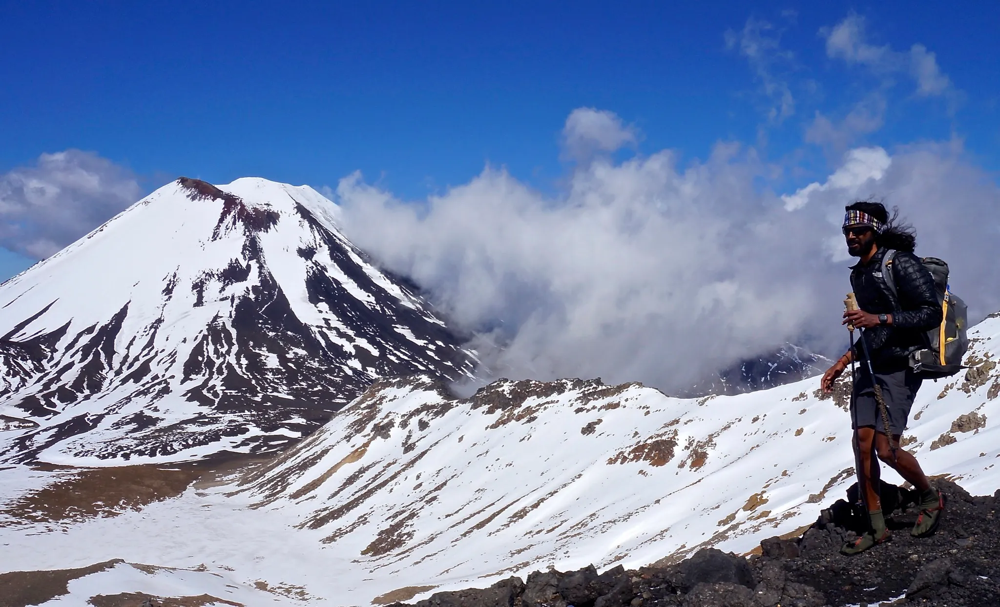
Weather: -4 to 7°C · dry · gusts to 31 km/hStanding at the summit of Mt Tongariro, I was filled with gratitude. I looked up to heaven and said, “Thank you.” Extremely humbled and blessed to have witnessed so much beauty in Tongariro National Park in New Zealand. Day 30: 1,158 km.
Mt Ngauruhoe, also known as Mt Doom, as seen from Mt Tongariro. An epic day with breathtaking views along Te Araroa. Dan and I did the Tongariro Alpine Crossing and summited Mt Tongariro in Bedrock Sandals. Mt Ngauruhoe was used as a stand-in for the fictional Mount Doom in The Lord of the Rings movie trilogy. Truly a dream come true.
The Tongariro Alpine Crossing has more than lived up to its claim as one of the best single-day hikes in New Zealand, if not the world. Here’s the view of Blue Lake, though it’s not blue coz of the recent snow dump. Considered sacred, it’s also highly acidic.
The Whanganui River
Weather: 11 to 14°C · 4 mm of rain · gusts to 67 km/hI had no cell reception or contact with civilisation for four days while canoeing over 160 km of the Whanganui River as part of Te Araroa.
The Whanganui River along the Te Araroa trail. One of the Great Walks in New Zealand. Definitely the best four days of my life.
Waterfalls like these adorn the entire length of the Whanganui River winding through the mountains to the Tasman Sea.
Mt Crawford, above the clouds
Weather: 2 to 9°C · dry · gusts to 32 km/hMy playground was above the clouds yesterday, overlooking the entire Tararua range and Taranaki along the Te Araroa trail from Mt Crawford. The mountains were holding up the clouds like a dam. One of those purely magical moments that overcome all the pain and exhaustion and make you completely NEW.
Wished for one of these moments and it was really happening. One of those magical moments at the summit of Mt Crawford on the Tararua range along Te Araroa. Eddie Vedder’s soundtrack song “The Wolf” rings in my head every time I’m at a summit, making me feel free.
And I’m back. The Tararua mountain range was beyond beautiful. Summited Pukemarawai, Twin Peak and Mt Crawford. Almost at the end of the North Island. Day 39: 1,623 km.
Wellington: the end of the North Island
Weather: 11 to 15°C · dry · gusts to 79 km/hIt felt unreal being at the southernmost terminus of the North Island in New Zealand, tramping the Te Araroa trail. 41 days of tramping, 1,686 km of mud, roots, rocks, forests, mountains and roads. So humbled and blessed to have met so many wonderful Kiwis who helped me along the way and got me here. To the South Island I go!
The rock at the southern terminus of the North Island reminded me of the rock at the end of Vol State. Thanks to God for enabling me with strength, health and courage to explore the unknown.
The Queen Charlotte Track
Weather: 8 to 12°C · 1 mm of rain · gusts to 72 km/hAlong the beautiful Queen Charlotte Track in the South Island on the Te Araroa trail. The view is getting better and better. Playing with the Kiwis, watching the dolphins jump in the Marlborough Sounds in the South Island. So happy.
A real challenge
Weather: 7 to 14°C · dry · gusts to 51 km/h“If you are going to face a real challenge, it has to be a REAL challenge. You can’t accomplish anything without the possibility of failure.” Laz, the race director of the world’s toughest race, the Barkley Marathons, told me this once.
It just feels so unreal looking at this beautiful view of Queen Charlotte Sound in the South Island of New Zealand along Te Araroa, but it’s even more unreal and humbling that I have already tramped about 1,753 km in 43 days. The possibility of failure is huge, even as I’m pushing body and mind to the limits, but it’s been a real challenge and I’m giving my 100%. Special thanks to my friend Dan for his continued support.
Snow in the Richmond Range
Weather: 6 to 14°C · 11 mm of rain · gusts to 79 km/hInto Mt Richmond Forest Park, and NZ weather is putting me to a real test. When I got to the hut, it was such a blue, sunny sky that I got my solar charger out to charge my phone, and within 15 minutes it was hailing and then it started snowing. I mean SNOWING. Never seen this kind of weather change in half an hour, but well, it can’t be a Real Challenge if it’s always sunny, aye! Day 47: 1,842.5 km.
Little Rintoul and Mt Rintoul
Weather: 2 to 10°C · dry · gusts to 70 km/hDan and I just summited Little Rintoul (1,643 m) and Mt Rintoul (1,731 m) today along the Te Araroa trail in Mt Richmond Forest Park. Lucked out on the weather and witnessed some stunning views of the Southern Alps.
The Richmond Range
Weather: 4 to 14°C · 4 mm of rain · gusts to 73 km/hHuts play such a vital role in sheltering trampers from gnarly elements all along the Te Araroa trail. Shelter, fireplace, bunk beds, firewood, that’s all you need when you are cold, freezing and starving. So thankful for the hut system in NZ. Here’s Porters Creek Hut in Mt Richmond Forest Park at the 1,900 km mark.
What kind of imagination did it require to bring such wonders into being? My mind was blown away trying to comprehend it all, and I found it easy to worship the Lord who showed Himself in such beauty. Taken at the summit of Mt Rintoul in Mt Richmond Forest Park in New Zealand. Day 51: 1,928 km.
Waiau Pass
Weather: -8 to 3°C · dry · gusts to 48 km/hMt Traverse (2,338 m) from Traverse Saddle (1,787 m) in Nelson Lakes National Park on the Waiau Pass Track of the Te Araroa trail. One of the most stunning mountains I have ever seen. So stoked to have completed the Nelson-Marlborough region of the South Island with Dan, all in Bedrock Sandals. Moving on to the Canterbury section tomorrow.
The surface flattened at the top of the Traverse Saddle (1,787 m) in Nelson Lakes National Park on the Waiau Pass Track of the Te Araroa trail. The light was bright, cutting through the clouds and illuminating the distant mountains and everything around it. The mountains and the Southern Alps were bathing in the sun all around in a spectacular way that I have no words to describe. Tears poured from my eyes and rolled down my cheeks uncontrollably. Mt Traverse (2,338 m) and the surrounding alps were beautiful beyond description. I wiped away my tears with my gloves, which froze instantly. I looked all around once again, darting one way then the other, trying to take everything in.
Climbing up a snow-encrusted scree field to Waiau Pass, the second-highest point of the Te Araroa trail at 1,870 m. Yes, I’m in my sandals.
Lake Sumner and the Hurunui
Weather: 4 to 12°C · 8 mm of rain · gusts to 96 km/hDay 60: 2,151 km. The Poplars Range, St James Walkway, Doubtful Range and Tekoa Range put me to a real test. All the heavy rains made the Taramakau River and Otira River crossings a living hell. Negotiated waist-deep, bone-chilling, fast water currents all day. Continually reminding myself that the challenge is in my mind and not in my legs and that this too shall pass.
“It’s an act of worship just to sit and look at high mountains.” — Sir Edmund Hillary
It takes a proud man to say he never needs any help. I give thanks to Christ and all the wonderful people He has placed along my path to help me get to where I am today. My faith has been the strength that has carried me through so much in my life.
Just about 850 km to go. Thank you, friends, for your continued support and motivation. Feeling humbled and truly blessed.
Why I was walking
Coming from an Asian country, I have seen things and I had the feeling deep in my gut that there’d been something I should have made, that would have made things better.
I guess now is the time.
There are millions of people who will go to bed in slavery tonight. Some will even die there. You can be a powerful weapon in the fight against this inhumane system of exploitation and abuse.
We will be running/tramping the Te Araroa trail, a trek across the length of NZ. That’s 3,000 km (1,864 miles) of sweating in unforgiving terrain, giving everything we’ve got, and pushing our bodies to the limit.
I have partnered with Rebekah Clews, who is also walking the Te Araroa trail, and together we are working with Tear Fund’s Project ACT to fight against human and sex trafficking and put an end to this epidemic that’s destroying lives all over the world.
Stunning scenery overlooking Lake Sumner in the Doubtful Range along Te Araroa in the South Island. Lucked out on the weather during this part of the Canterbury section.
One of the most glorious sunsets I have witnessed in the Canterbury section of the Te Araroa trail in the South Island, New Zealand. I would have soaked in this view for hours if not for the ravaging, bloodthirsty, evil and monstrous sandflies.
A much-deserved hot stream soak for the puppies along the Te Araroa trail, on the walk towards Harpers Pass in the Hurunui River.
The Pinnacles, on my birthday
Weather: -7 to 4°C · 1 mm of rain · gusts to 38 km/hDidn’t even realise it was my birthday until noon today. Had such a beautiful day in Arthur’s Pass National Park and Craigieburn Forest Park tramping along the Te Araroa trail. God gifted me with some stunning views of the mountains and beautiful weather to enjoy the day. Great weather, hot ramen noodles and good company. Can’t ask for more. Filled with so much gratitude and so damn happy to start another great year by witnessing so much beauty. I’m a lucky man. Thanks, everyone, for your continued love, support and wishes.
Stunning view of the Pinnacles, on the Harper River Track, along the Te Araroa trail in Craigieburn Forest Park. So damn lucky to be alive and witnessing such beauty. That one time I totally forgot it was my birthday. This view totally heals all the pain and exhaustion.
Sitting at the mouth of Lake Constance, en route to Waiau Pass, looking at this view, you feel so insignificant. This is what happens to problems when you are in the mountains. They become insignificant.
Looking back. Your birthday is one of those days you never forget, even if you don’t celebrate it. But on Te Araroa I almost did. It was one of those mesmerising days: stunning scenery, surrounded by beautiful wildflowers. I didn’t realise it was my birthday until noon, that’s how great a day I was having. That evening, at the end of the day, I sat in a hot tub where we’d checked in for the night.
The Clent Hills
Weather: -3 to 2°C · 11 mm of rain · 1 cm of snow · gusts to 125 km/hThe view from the top of the Clent Hills Saddle (1,480 m), with a clear view of the spectacular Longman Range, en route to Manuka Hut along the Clent Hills track of Te Araroa. Tussocks and spear grass devastated my feet, but stunning views like these totally made it worth the pain. Day 64, for a total of 2,292 km.
“The hardest thing in the world is to simplify your life. It’s so easy to make it complex. What’s important is leading an examined life.” — 180° South
This has been my favourite pastime tramping Te Araroa. After a long day of hard tramping, once we get to a hut, I build a fire, read my favourite book while sipping hot tea, and fire-gaze. Loving the simpler life.
Lake Tekapo
Weather: 2 to 8°C · 5 mm of rain · gusts to 73 km/hDay 68 of Te Araroa with 2,371 km in the bag. The day ended with a gorgeous sunset at Lake Tekapo. It’s stunning views like these that make me want to get out there every day, enjoying the beauty, the exhilaration and the camaraderie with Dan and other fellow trampers. So bloody lucky to be witnessing so much beauty.
Four days after the finish, I wrote this about that night:
Not too long ago, I was sitting on that rock by Lake Tekapo, worried, afraid and filled with doubts. It was freezing out there, but I didn’t care, as my fear of losing kept me fired up and warm. My dream of completing Te Araroa was vanishing just like the setting sun. The alpine glow on the distant mountains over Lake Tekapo was stunning, but on the other hand my inflamed feet from the fall along the Two Thumb track didn’t look happy. Flipping through my Bible, the words popped out: “Do not be afraid — I am with you! I am your God — let nothing terrify you! I will make you strong and help you” (Isaiah 41:10).
I just can’t let fear take over. I need to believe that I can do this. Believing in God’s word with a childlike faith, I decided to never doubt but instead to rely on Him, keep the focus on the finish line, take it one day at a time and keep moving. Fear can be a stimulating factor as long as you take advantage of it. It can extend you beyond what you regard as your capacity.
It’s been four days since I completed Te Araroa and all I remember is the tears of joy at the finish line and the sense of accomplishment. Thank you all once again for your kind words and support throughout my journey.
The injury
The going is getting slow even as my left foot is trying to recover from an injury that I sustained during a nasty fall while tramping muddy tussock terrain along the Two Thumb track. The challenge has definitely begun. Time to HTFU and keep moving.
Stunning view of the alps from the outhouse (shitter house) of Camp Stream Hut along the Two Thumb track of Te Araroa. Hard to do the job with the door closed, especially with a stunning view like this.
Lake Ohau
Weather: 8 to 16°C · 19 mm of rain · gusts to 72 km/hLake Ohau along Te Araroa. A stunning glacial lake in the Mackenzie Basin of New Zealand’s South Island. Up until this point we had great weather, and then bone-chilling wind and rain started pouring in. NZ weather can be full of surprises. One more track and we’ll be done with the Canterbury section and will head into the Otago area.
After a long day tramping in nasty gusts and rain, we found an epic site overlooking Lake Middleton. It’s bone-chilling cold. Didn’t realise a hot cup of ramen noodles and tea could make me so happy and content. The camaraderie makes it all the more special.
The Ahuriri River
Weather: 5 to 19°C · dry · gusts to 48 km/hThis may be my last post about my injury. It hurts and there’s nothing much I can do about it. I have given my everything for this expedition and all I can do now is suck it up, HTFU, take it one day at a time and keep moving. God help me get better and fast. Glad that I’m safe, surrounded by good friends, Dan and Rory, and still moving. The challenge has begun. Thanks for all your prayers and support!
Witnessed stunning views of Lake Ohau before starting the Ahuriri track of Te Araroa. Lake Ohau, in the Mackenzie High Country, is cradled between the Ohau Range to the west in the Main Divide and the Ben Ohau Range to the east.
A well-earned rest on top of the saddle past Freehold Creek along Te Araroa. Dan soaking in the view just before starting the massive and long descent to the Ahuriri River. What happened at the river basin is another story which turned out to be a great adventure!
Crossing the Ahuriri River proved to be a real challenge along the East Ahuriri track of Te Araroa. Heavy rains and the snowmelt made the crossing deadly and totally impossible. After a long day tramping, we decided to take it easy and call it a day. Climbed a steep hill out of the river basin into a private pine tree forest and pitched the tent only to realise that we had no water to cook our precious noodles :). Here’s the view while crossing the river from Ireland Road bridge! A detour that added 10 km to our long day.
Lake Wanaka and the Motatapu
Weather: 5 to 13°C · 4 mm of rain · gusts to 75 km/hLone tree along Lake Wanaka on our way to Glendhu Bay along Te Araroa to begin the Motatapu Alpine Track. Views like these make me realise how bloody lucky I am to be here witnessing so much beauty.
View of Mt Motatapu and Mt Hyde from the top of Rose Saddle (1,270 m) along the Motatapu Alpine Track of Te Araroa. The river was named Mota (River) Tapu (Sacred) by early Māori, who used the Motatapu valley as an access route for food gathering and for the movement of Pounamu (Greenstone). This track is a knee buster when it comes to downhills and really put Dan and me to the real test. It offered stunning views of the entire Motatapu Valley and the surrounding mountains though.
2,607 km at the moment and 388 km to go. Less than a Vol State!
The Motatapu Alpine Track proved more challenging than I had imagined. The downhills were definitely a knee buster. Day 76: 2,671 km, with about 325 km to go!
So close
Weather: 5 to 12°C · 4 mm of rain · gusts to 72 km/hView from the North Mararoa River along the Te Araroa trail in Southland. So close to the finish line. Almost there with Dan to Bluff.
I’m a hardcore fan of J.R.R. Tolkien and The Lord of the Rings, which was a big inspiration for my move to New Zealand and Te Araroa. At the start, along Ninety Mile Beach, I picked up this beautiful scallop shell, initially to carry as a souvenir of my journey and then throw away at Bluff, and I started calling it “My Precious”. Like Frodo, I’m being taken over by my precious, and the temptation to keep it is increasing day by day. With just about 150 km to the finish line, every day has been a battle getting to Bluff, but I hope I HTFU and let go of the precious.
Longwood Forest, and the last night in the tent
Weather: 10 to 19°C · 5 mm of rain · gusts to 70 km/hDay 85: 2,932 km.
What a person the Lord is to have helping you!
My Precious and I made it safely to Riverton. Had a very peaceful time in Martin’s Hut along the Longwood Forest track. All that is left is 64 km.
Through my injuries and hardship, the Lord has been faithful to His promise, “And be sure of this: I am with you always, even to the end of the age.” One verse that I read every night before going to sleep.
Just another day tramping the Te Araroa track in New Zealand. Here’s Dan negotiating his way through electrified barbed wire on farmland as the ladies are staring at his butt, while exiting the last forest track, Longwood Forest, in Southland.
Can you see the pole right in the middle of the puddle? That’s a full 5-ft-long pole with only the handlebar visible. That’s what I call a tussock landmine, and some sections of Te Araroa are full of them. One of them got me real good and caused me serious injury. NZ tracks are not to be taken lightly.
Pitched our tent in the wild one last time along the Te Araroa trail. Bluff bound with just 60 km to go.
Oreti Beach
Weather: 9 to 16°C · dry · gusts to 45 km/hMy Precious and I strolling along the beach towards Bluff. At the start of Ninety Mile Beach, a walking song from The Lord of the Rings was playing in my head, and I wrote it down in my journal: “Home is behind, the world ahead.” Just a few more beach sands to tread, and then the world behind and home ahead.
Bluff
Weather: 7 to 19°C · dry · gusts to 30 km/hMy Precious and I having our last cup of coffee together. My Precious is still trying to talk me out of destroying it, but I’m staying strong and determined. Mordor bound, I mean Bluff bound.
It is done. 87 days 21 hours 28 min 56 sec. A feeling of both relief and joy flooded through me as I thought about all the planning, setbacks, happiness and disappointments in finishing Te Araroa. I’ve never had to call upon such deep determination and resolve in all my life, especially after my injury. This would not have been possible without God’s grace, the wonderful help of trail angels, and above all my awesome friend Dan.
Massive thanks to Bedrock Sandals and to Dan for believing in my dream, and to Huckberry, Gossamer Gear, NEMO Equipment and Yama Mountain Gear for equipping us with the best gear. Finally, a massive thanks to every one of you for your kind words, encouragement and support, especially during my dark times. Much gratitude. Thank you!
Friendships were being forged, around a stove, by a campfire or a wood fire in the hut, after chowing instant noodles, cookies and some cheap red wine on lucky days. So many friendships made along the way, but I’ll treasure Dan’s the most. This finish line picture says it all. It was published in the Southland Times, and it’s my favourite.
It is done! I have run out of earth to tread. Literally. I’m at the very end of the South Island. I guess I’ll go home now!
For the curious minds: the precious is gone. I narrowly escaped with it, just like Frodo saying, “The Ring is mine.” Took one good look at it. It reminded me of the very first day of my Te Araroa journey, when I picked it up, and here I am at the very end of the island after a 3,000 km journey through Middle-earth, living like a hobbit. My Precious, my sweet burden, is gone, sitting under the ocean, where it belongs.
I wish the Eagles had shown up to carry me home!
Mt Doom, and a new year
Celebrating all the mountains and peaks of my life. The places where all my best dreams have come true, the cathedrals where I practice my religion. Going to the mountains is going home. Happy International Mountain Day. Go climb a rock.
It’s been 20 days since completing Te Araroa and it feels so unreal reflecting upon the journey and the determination it took to finish. I am travelling now, meeting people who helped me along the way, cooking some Indian meals, sharing stories and laughter. A little something I could do to thank them for their love and generosity.
Climbed Mt Doom (Mordor) in Middle-earth to witness the first sunrise of the New Year. Literally! I get to see the first sunrise before the rest of the world. Though one does not simply walk into Mordor. Freezing cold rain, mist and gusts tried to stop me from getting to the summit. In the end, I had no precious to throw into the fire, only to sit back at the summit, enjoy this precious view and welcome the New Year with much gratitude and in anticipation of what’s ahead. Happy New Year, everyone!
First sunrise of the year 2015 from the summit of Mt Ngauruhoe aka Mt Doom aka Mordor. It’s hard to put into words the emotion I was going through witnessing this sunrise. I was filled with doubts, yet I continued following my dreams, which eventually brought me to this place. A very special moment, and I’ll carry this with me as a gift from God and in anticipation of what is to come this year.
I can now say that I went all the way to the end of Middle-earth.
Watched The Hobbit like a hobbit. OK, I may be a bit tall to be one :)
I just didn’t want the movie to end. The Hobbit: The Battle of the Five Armies was simply stunning. Even more stunning to watch the Middle-earth saga in Middle-earth after tramping the length of Middle-earth. Feel so bloody lucky and blessed.
San Francisco bound. My plane is painted as Smaug. It reminds me that “anyone can be courageous.” Craving some cheeseburgers and Dr Pepper.
About the map: The Te Araroa trail. Each day's stretch follows the trail, from where I stopped the night before to where I stopped that night; the dashed line is the ferry across Cook Strait.
The weather under each day is from the Open-Meteo historical archive (ERA5) for where that day ended: the weather of the area that day, worked out from observations, not a reading I took on the way. Up high it could be colder and wilder than the numbers say.
Comments
No comments yet. Be the first.